Machu Picchu, Peru
2022
-
Aguas Calientes, which can be reached by train from Cusco and closer places, is the town nearest to Machu Picchu. From the center of this small town along the Urubamba River, one can take a bus up the steep, one-lane dirt and gravel road with switchbacks to the entrance to Machu Picchu. Some people prefer to hike up.
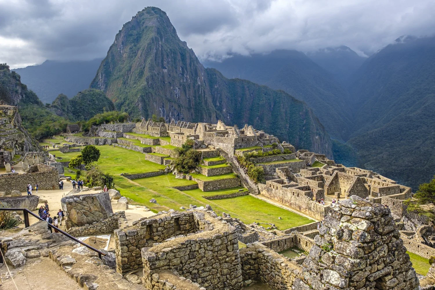
It does not take long after arriving at Machu Picchu to understand why this Incan city, on a saddle ridge between peaks in the Andes, is one of the seven modern wonders of the world and is protected as a UN World Heritage site. Machu Picchu’s construction probably began around the year 1440; experts believe it was built as a royal Incan estate. It was abandoned – for reasons that are still a mystery -- around 100 years later.
As the Incas left no written records, many questions about them and Machu Picchu remain unanswered. The Spanish, who invaded Peru in 1532 and controlled it into the early 19th century, apparently did not know about Machu Picchu. It was a lost city, perhaps part of a lost region, until accidentally discovered in 1911 by Hiram Bingham, a US citizen who became fascinated with Incan archeology while in Peru studying. Bingham was exploring for another Incan city when he found Machu Picchu.
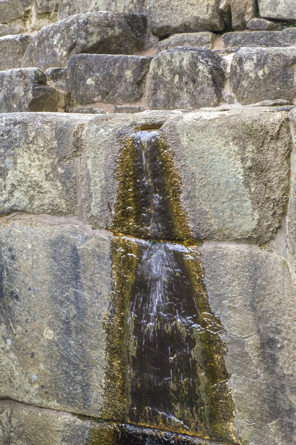
Although Machu Picchu covers about 80,000 acres, the central, built-up core, or “citadel”, is compact and roughly only around 25 acres. It has sacred, agricultural and urban centers and about 200 structures in total, including houses, baths, temples and sites for rituals, sanctuaries, and one or more structures used as a calendar or for astronomical observation. There are terraced areas for animals and agriculture that supplied the city’s population – perhaps 700 to 1,000 Incas - with food. The Incas built stone canals to carry water from underground springs on the peaks above the citadel to the agricultural area and throughout the citadel. Stone fountains (16) still distribute water from the canals to the housing and sacred areas.
The citadel is an architectural wonder. Boulders were moved to the site without wheels. The stonework of the structures is extraordinary. Experts still question how the Incas could obtain such fine edges on stones that were cut to fit together precisely and without mortar. A human hair does not fit in the cracks between many of the stones.
The map below this section shows the “high circuit” (red line) and the “low circuit” (blue line) of the recommended walks on the citadel. The “high circuit” provides excellent views over the citadel and toward the peaks at its northern end. The “low circuit” offers more time in the central parts of the citadel and leads to the paths to the peaks at the citadel’s northern end.
At the citadel’s northern end is a path leading to a guarded entrance that the map labels “control booth.” After the booth are trails that on the left lead up to Huchuy Picchu and on the right up to Huayana Picchu (aka, Waynapicchu). Huchuy Picchu’s peak is not much higher (160 feet) than the citadel. The round trip is a little more than one mile and can be traveled quickly. On the other hand, Huayana Picchu’s peak is, at 8,835 feet, almost 1,000 feet higher than the Machu Picchu citadel. Estimates to climb to this peak and return begin at three hours, but a fit young person can do it in much less time. A Machu Picchu entrance ticket can include a hike up one peak or the other, and only 200 people are allowed to climb Huayana Picchu a day.
The following photos, which were mostly taken while on the two circuits, capture parts of all three citadel sectors, their buildings and open spaces. Among the structures pictured are the Main Door, the House of the Terrace Caretakers (or Guardhouse) in the agricultural sector, the semicircular Sun Temple (only structure with curved walls) with the Royal Tomb at its base, the Temple of the Three Windows, a fountain, and the Water Mirrors. The Water Mirrors are two bowls chiseled out of the in-place granite that became a floor. The current theory is that Incas poured water into the bowls and then at night looked at the reflections to see the moon and sky. In effect, they were astronomical observation tools.
Machu Picchu allows a fascinating step back into an ancient and partially lost history. There is much to photograph and, as some of the images show, the frequently changing weather and light of the high altitude can present challenges and opportunities for a photographer.